The Big Pine trail Wanakena
Google maps link: https://www.google.com/maps/@44.1446791,-74.9038683,16.31z
I had heard a lot about Wanakena’s “Big Pine”, but only recently had a chance to make the trek. It was a great January day to snowshoe. Cold enough that the snow was firm, warm enough to leave my coat in my backpack. The tree certainly does live up to its status. This trail also takes you to a floating bog, and a side trip to Aspen point on the Oswegatchie is easily added on.
History
There is so much history in Wanakena, that I could go on for days to cover it. I’ll try to be brief and give a bit of insight into what is relevant to this trail.
Before the 1860’s the area was only known pretty much to woodsmen and guides. This region was referred to as the South Woods (along with Cranberry Lake and Tupper Lake). There were only trails to the region. About this time a stage-coach line worked its way to the region from Canton NY, a two-day rough passage. This route was the beginnings of what we now know as the Tooley Pond road. Mining was starting in the region as well and this brought more people to the area. In 1867 a dam was built on Cranberry Lake, raising the level of the water. This made the lake even more attractive to the fish & game. The Carthage & Adirondack railroad had expanded its rail into Benson mines (in the town of Clifton) by 1889. Within the next year, a road was constructed from Newton Falls to Cranberry Lake. All of these played a part in the growth of the area as a tourist destination.
In 1901, brothers Herbert & Horace Rich, (the Rich Lumbers Company) experienced lumber barons made their way here to look for timber. 16’000 acres were purchased and construction started the next year. The village was built on the banks of the Oswegatchie River, which flows into Cranberry lake. As was a common practice of the time, when the timber was gone- so was the company. In 10 years’ time, the Rich Lumber Company had used up the resources and moved to new forest holdings. The mills closed and people moved away. Somehow during all of this, the big pine (and several other fine specimens as well) missed being cut for timber.
This was a turning point for the forests, as the Ranger school came into being, and the state started buying up the logged over forests. Between the two entities, pretty much all of the forests were now in caring hands. The forests were replanted and managed for sustainable forestry. Today we take this as a given, but at that point in history, conservation was a brand- new mindset. The regions woods & forests that we enjoy today are a direct result of these happening, and those forward-thinking people that pushed for positive change.
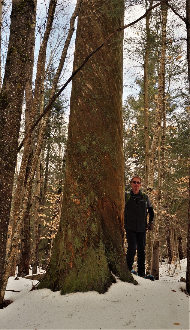
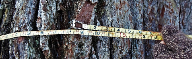
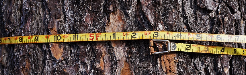
The tree of topic is an eastern white pine-Pinus strobus. White pine has long been a very important softwood in the lumber industry. In this area, it is by far the most commonly used tree for lumber production. The big pine has survived many storms and events- yet still stands tall and proud. In recent years this includes the 1995 microburst and the ice storm on 1998. Professional measurements show that the tree is over 140’ tall, and over 14’ in circumference. This puts the tree’s diameter at about 4 ½ feet thick @DBH (diameter at breast height, 4 ½ ‘). Using These measurements, and a formula to calculate its age places this pine at around 270 years old. That age predates the American revolution. Note that these approximate, and even the professional measurements varied by a small factor. Regardless of these slight variations, the tree is thought to be in the top five (in regards to trunk volume) in New York state.
For more on the process used to age this tree:
https://www.hunker.com/13428895/pine-tree-diameter-vs-age
Getting there
From New York State Rt. 3, turn onto St. Lawrence county RT. 61. Follow this, continuing straight onto Main street. This will take you across a bridge, (which at one time was a train trestle) and onto the South Shore road. Around ¾ of a mile ahead, you will find a trailhead on your right. This is the Five ponds & Pepperbox wilderness trailhead. This is the second trailhead on this road. The first one is near the playground and water plant. Keep following the South Shore road to the end. Just before the road ends, you will see the remnants of an old woods road on your right (East). This is blocked to prevent traffic with boulders in a short distance.
On the trail
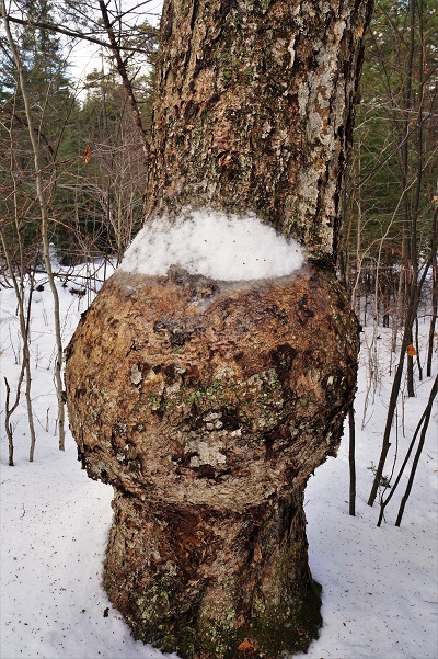
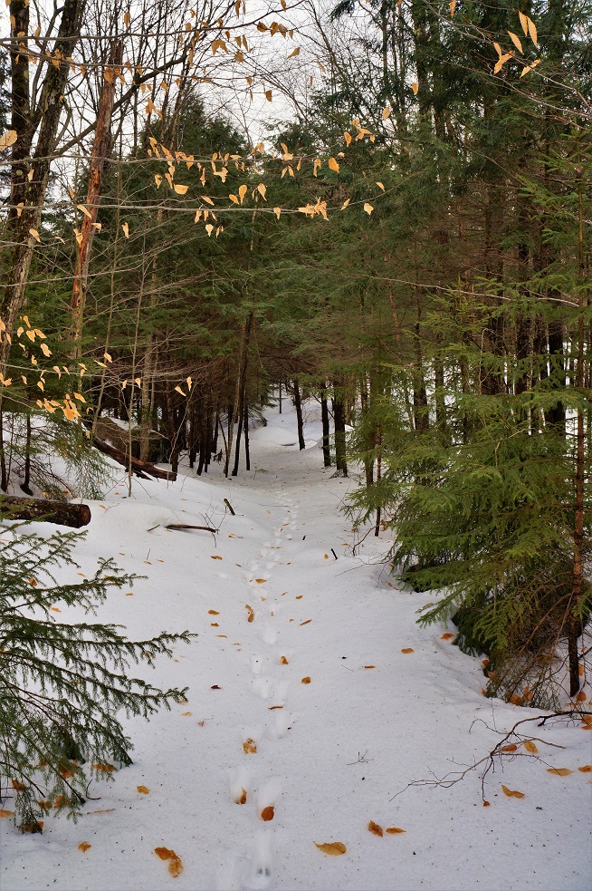
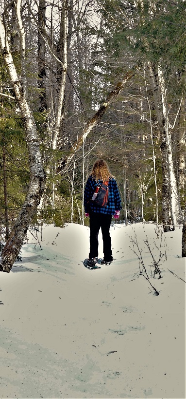
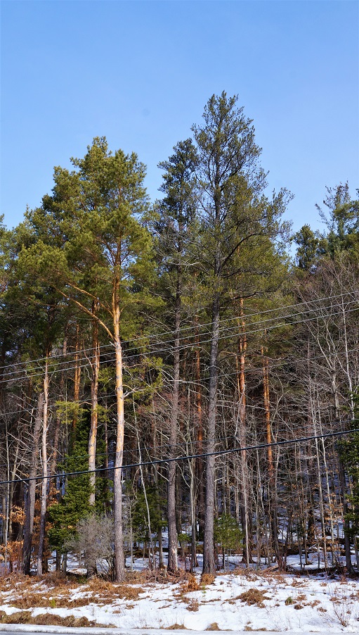
From the South Shore road, you will head east through some mixed hardwoods and a few small evergreen patches. The trail is pretty level, and pretty easy to follow. The trail is perfect for snowshoeing, and we were glad to have them. While the snow wasn’t very deep, there were plenty of icy sections, and the traction of the snowshoes made it much easier. The trail is sporadically marked with small orange pine tree shaped markers. There aren’t many- but it’s still easy enough to find your way. You will notice some pretty big trees mixed in with smaller trees. You will notice some dead but still standing trees that are massive in their own right. I stopped to check out one white pine, and it measures just under 12’ around, DBH. I also found a yellow birch with an incredible burl, a few feet of the ground.
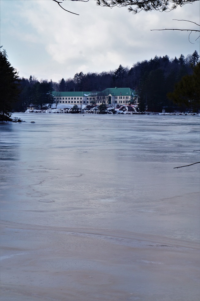
At 6/10 of a mile from the trailhead, a trail joins the one you’re on. This trail goes North to Aspen point, on the Oswegatchie River. This trail is about 1/3 of a mile long and leads to a point across from the Ranger school. This is a popular route to get to the big pine from the Ranger school or the river. There is a dock here for those arriving by boat. I understand that people also snowshoe across the river when the ice is thick enough. We took this trail on the way back.
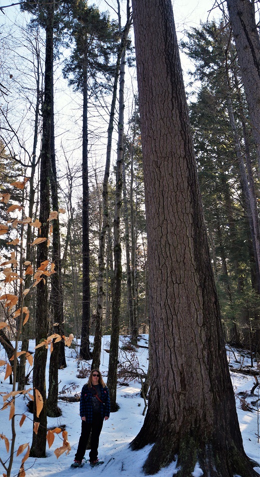
 Back on the main trail, you will start to head to the south. At just one mile in, you’ll find the big pine on your right, about a dozen yard off the main trail. This tree, as big as a factory’s smoke-stack is plain to see. Measurements that I have read, state that the first branch is 74’ off the ground. This tree is pretty impressive, to say the least, and pictures really can’t seem to do it justice. The tree is very straight and has very little taper. To get an idea of the amount of wood in this tree, its volume is thought to be around 1,000 cubic feet. This converts to 12,000 board feet. To put this into a real-world perspective, that would yield over 2,250 eight-foot 2×4’s.
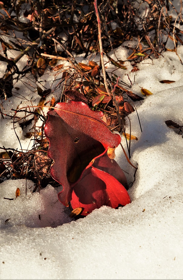
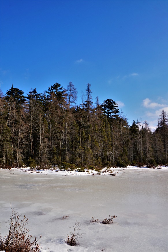
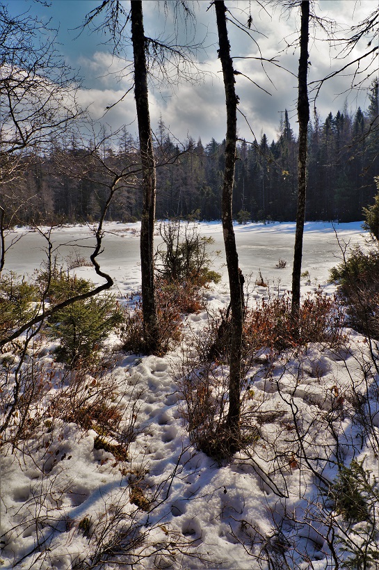
Back on the trail, we continued on another 5 minutes further down the trail to a small bog, probably four or 5 acres. This is ringed with Spruce, Tamarack & Fir trees. This was a beautiful spot on the day we were there. It was in the mid-’30s, no wind and a very sunny. It was just one of those special time & place moment’s that you wish would never end. As I was looking around, and snapping pictures, I noticed a pitcher plant (Sarracenia purpurea) sticking out of the snow. These are a carnivorous plant, and the only one that can survive the north country climate.
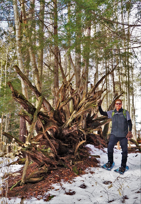
From here we backtracked and took the side trip to Aspen point. Along this trail, we came across several old blow-downs, and one had a particularly impressive stump. The point itself is a great stand of mature Hemlock and White Pine. There is a dock here for the boaters, and you have a great view of the Ranger school 1/3 of a mile across the river to the west. From here we backtracked to the main trail, and then back to the trailhead on the South Shore road.
All together we snowshoed 2.7 miles round-trip. This is a pretty easy trip and would be very kid friendly. I hope you get a chance to make this trek yourself. Trees like this are very rare, and won’t last forever. It is hard to believe that the forest was once full of trees like this. It’s also hard to believe that this tree (and a few others) missed the logger’s saws, given the scale of timber harvesting that went on here early in the 20th century. Even driving up the South Shore road, you’ll see hemlocks that are considerably bigger than you will find most anyplace else.
Speaking of big trees….
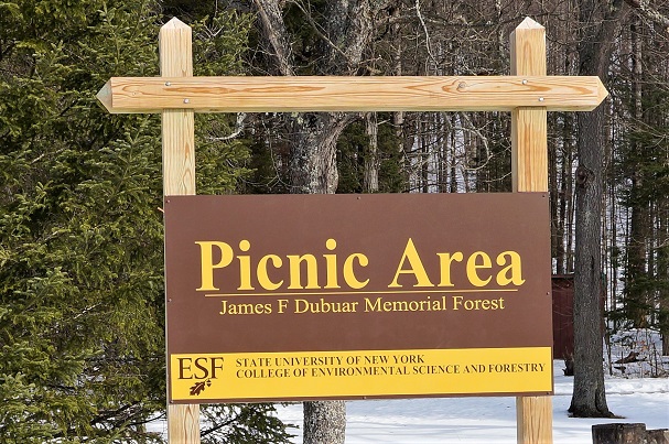
While researching the big pine trail, I came upon some information about a Jack Pine (Pinus banksiana) nearby. It turns out that this tree is the largest Jack pine in New York state, and in its natural range. I was able to contact someone from the Native Tree Society, who was gracious enough to give me coordinates and information on this tree. The tree is 93 feet tall, and over 5 feet around. While not near the size of the “big pine”- it is still the largest of its kind around. It’s kind of like comparing the biggest deer and the biggest rabbit (apples & oranges). This tree is located in the James F. Dubuar memorial forest on RT.3, between Star Lake and Wanakena. This park is on the site of the former Civilian Conservation Corp (CCC) camp S-28. Undoubtedly this tree was planted by the CCCs that called this place home. This camp was in use from 1933-1938 and was responsible for many of the forests you see in this area today. The fact that this tree is the largest of its kind, and growing where it is, is very neat, to say the least. It is a nice little park here, and worth stopping for a picnic and a cold drink of pure Adirondack water that runs 24/7 from an artesian well. There are several fireplaces and picnic tables here, as well as an outhouse.
For more on Wanakena, follow this link- https://hikingthetrailtoyesterday.wordpress.com/2017/02/22/wanakena/
Special thanks
I would like to thank Elijah Whitcomb for his help in locating the Jack Pine on the James F. Dubuar memorial forest, and for some of the measurements of the big pine (from the Native Tree Society forum). His assistance added some vital parts to this article.
References & Sources
New York State D.E.C.
http://www.dec.ny.gov/lands/34719.html
Native Tree Society
http://www.nativetreesociety.org/
Clifton Fine ADK
http://www.cliftonfineadk.com/bigpine
ESF Wanakena Ranger School
http://www.esf.edu/rangerschool/centennial/dubuarmap.pdf
New York State D.E.C
http://www.dec.ny.gov/lands/34719.html
Hunker
https://www.hunker.com/13428895/pine-tree-diameter-vs-age
About the Author
I am a life-long resident of the north country, calling Edwards my home. I have always had a passion for the outdoors, and for local history. I recently started this site to share places that have been part of our local history and heritage. I hope you get a chance to hike some of these trails for yourself and reflect on the rich history of those that walked here before you. And if not, sit back and experience these from where ever you are right now. Either way, enjoy!
All Rights Reserved

Nice post. I learn something new and challenging on websites I stumbleupon every day. It will always be exciting to read through content from other authors and use something from other sites.
LikeLike
For many years my uncle had the camp at the end of south shore rd. I have been up that trail from a child up and have seen those large trees. They are amazing. I think some have been down in the past few yeas!
LikeLike