Stone Valley trails
Google Maps link- https://www.google.com/maps/place/The+Stone+Valley+Trail/@44.5543972,-74.9401848,15.5z/data=!4m5!3m4!1s0x4ccc890e8deeb6bb:0x4a87c9d5e561c9e9!8m2!3d44.555557!4d-74.9387258
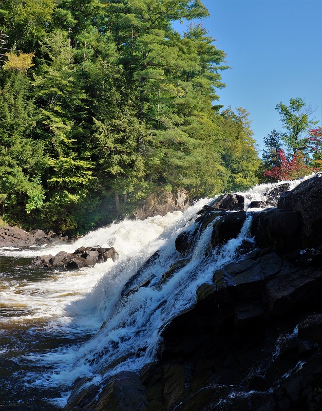
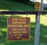
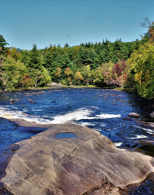
I have heard a lot about the Stone Valley trail and finally got a chance to see it for myself. It didn’t take long to see why people speak highly of this trail. I also could understand peoples love for the Raquette River. Water power was one of the first things needed to run the mills that would be necessary for the start of a community. Colton had that in a major way. This water power on the Raquette river was not only important in the towns early years but also would shape things in later years as well. The Raquette River is the heartbeat of Colton. So, like many of the places I hike, this is more than just a great trail, but also a trek back in time. This trails system is a cooperative between the town of Colton, Brookfield energy, the New York state D.E.C., St. Lawrence County and the Laurentian chapter of the Adirondack Mountain Club.
History
 Colton was officially made a town in April of 1843. It originally included the townships of Sherwood, Harewood, Granshue, and Matildaville. Through the years the size and boundaries would change and eventually include Stark, Jamestown, Oakham, and Hollywood. The Raquette river would also change its boundaries. Dams along the river would change not only the landscape but peoples address. In the case of Hollywood, it would simply not exist after the dams flooded the area for hydro-electric powerplants.
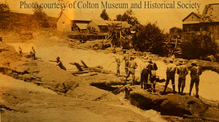
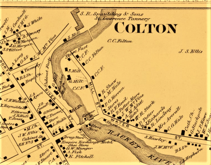
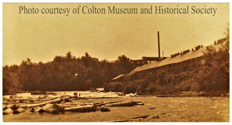
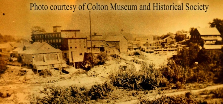
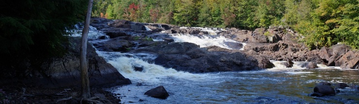
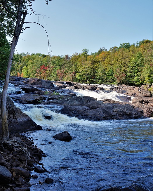
The river had many falls in the pre-dam years near the center of the town. This water power was quickly harnessed and created the industries that would serve Colton for years to come. It was said that the river had a fall of over 200 feet within the first mile. The first of these was a sawmill built by Horace Garfield, in 1825 and a gristmill built in 1828 by 1825 Horace Garfield. These are almost always the seeds from which a community grows, and from these seeds- Colton did grow. Both sides of the river became covered with mills and factories. The 1865 Beers atlas shows three sawmills, two tanneries, two grist mills, a starch factory, and several cabinet factories. There would be a pulp mill, and millstones from this can be seen at the Stone Valley’s Riverside drive entrance today.
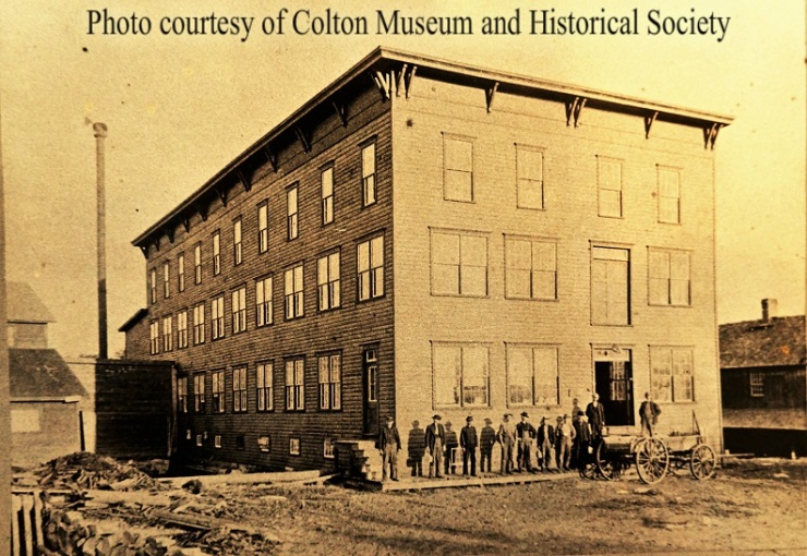
One of the more important commercial enterprises along the Raquette was the S.R. Spaulding & Sons St. Lawrence tannery. The building was 400’ by 42’ and had 300 tanning vats. Thirty-five men were employed at the tannery itself, while the hemlock bark needed for the tanning process would require great manpower to keep the place supplied.
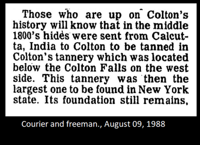 A hundred teams or more were needed just to deliver the bark. Loggers to cut and bark the trees, teamsters to drive the teams, blacksmiths and harness makers were all needed in large numbers. 5000 cords of hemlock bark were used annually for tanning, along with 500 cords of wood to heat the workplace. The leached bark was also used to produce the steam for heating. It’s easy to see how important just one of the town’s industries was to the local economy. This tannery was said to have hides from all of the country and the world. Buffalo hides came from the western states and even Calcutta India. In 1877, 16,000 hides were shipped in from the western plains.
One of the sawmills was a gang type mill and had 70 saws operating in 1850, and two years later another was built across the river on the west bank. A veneer mill was in operation and 1893 saw the start of the Raquette River Pulp company. The new pulp mill was able to process 30 tons daily.
 As the years went by, most of these businesses came to an end for various reasons. The transportation cost to ship out their finished products was an ever-increasing cost. The forests that produced the logs for the mills and the bark for the tanneries were used up. There was no such thing as sustainable forestry in those times, so when the forests were gone, so were the mills. Natural resources were not looked at with any concern for the future. Fortunately for us, this isn’t the case today, and the efforts of those in the early twentieth century have regrown strong and sustainable forests for us and our future generations to enjoy.
1952 saw another big change to the area with the Raquette River hydro development project. This would create six power dams and change the Raquette from a river to a series of impoundments. These did create some employment in the area and helped bring focus to the region in the form of summer camps and recreation opportunities. These places were logged off to salvage timber that would soon be underwater. As mentioned earlier, one of the places to be lost was Hollywood. This small community was the home to loggers and woodsmen, and also the Hollywood in. Before the advent of the automobile and paved roads, the stagecoach was the means of travel for those traveling between Potsdam and Tupper Lake. It was a two -day journey, and the Hollywood in was at the halfway point between the two. Later this in would become the Hollywood Dude ranch, owned by the Fuhr family. They would run this establishment to the delight of hunters, fishermen, campers, and vacationers until it came to be covered by what we now know as Carry Falls reservoir in the early 1950s.
Colton has a very rich history, and I have tried to just highlight a little bit of it that relates to today’s hike. This hike is still very much tied to the hydro-electric industry, with a dam at Colton controlling the flow of the river.
Getting there
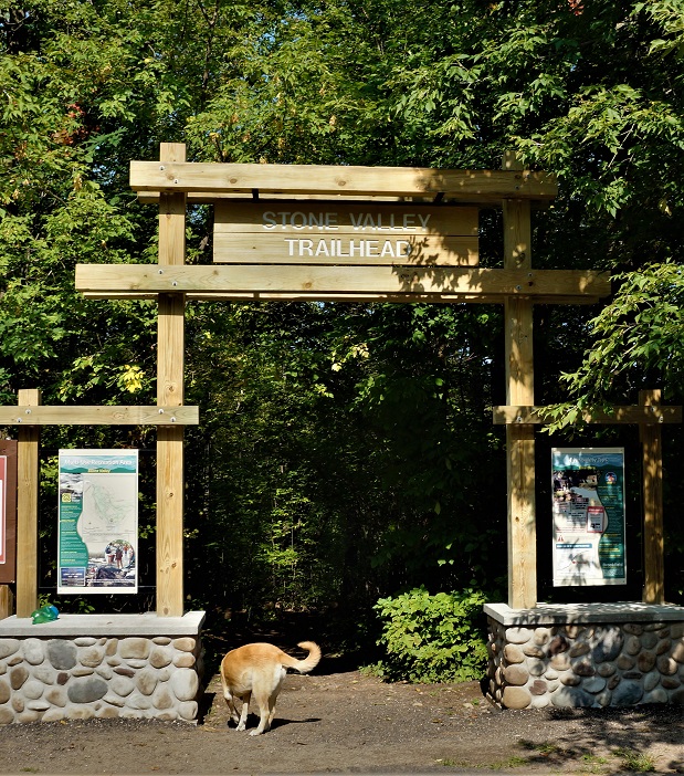
From NYS highway RT56 in Colton NY, head northeast on Main street. After crossing the bridge, turn left on Riverside Drive. Drive past the fire station to the end of the street, and you’ll find the entrance to the Stone Valley Cooperative recreational area. This is where we started our hike from, although there are several other trailheads available. You will come out about a quarter mile back across the bridge that you drove in on. This is on River Street, right next to the Colton Museum and Historical Society building. You can start your hike here if you choose. There are also several trailheads downstream- but to avoid confusion, I’m going to leave those out for now.
On the trail
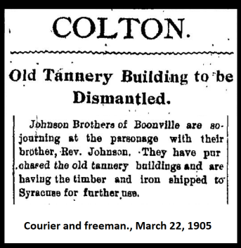
From the trailhead, you will start downhill in a northern direction. In a short time, you come to the first falls. As you head along downstream, you will find several trails coming in from your right. A couple of these looped around and didn’t do much except add distance to what we were trying to do. Keep to your left, and you will do fine. The trails themselves are in great shape and a lot of time was put into the construction. There are informative placards located at the high-points. You will find names like the tub, the narrows, High terrace, the gut, and the tannery ruins. Each one has a different look and appeal.
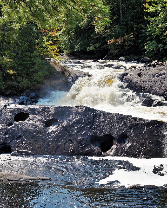
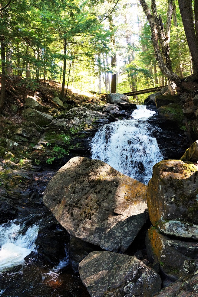
The tub is a series of glacial potholes. The Narrows is just what you would expect – a choke in the river with a great overlook. Eventually, you come to a great stand of pines, with a small brook flowing through them. Past the footbridge, the stream falls downhill to the river. This is Cathedral Grove and O’Malley brook. From here the river becomes calmer and shallower.
The trail will lead you past someone’s house and out to the Lenny road near a power line. At this point, you are about 4 miles from the start. It may be a little shorter next time, but we took a couple of the rights instead of lefts, and probably increased our mileage a bit. Continue to your left (west) along the Lenny road to the four corners.
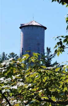
 You will notice a water tower across the river, and keep that in mind- because you are heading there. This is the Brown’s bridge road (or the Russell Turnpike/ county RT 24 depending on your map). Turn left and cross the bridge. After the bridge, there is a driveway on your left leading into the Brookfield power plant. Follow the driveway past the plant, and turn left at the gate, and past the plant, you will find a small clearing on top of a grade. You will need to turn right here. The trail is poorly marked, but you can follow an old truck trail for some ways. It becomes hilly through this section with many hemlock trees. Eventually, you will see a sign for O’Malley Brook overlook & Brown’s Bridge. Although you see the same river and falls, the view from the other side is brand new.
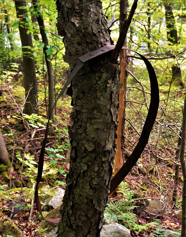
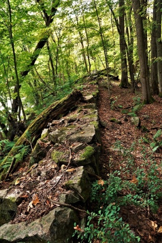
As you get close to the end, you will come to the tannery ruins. The stone foundations are pretty much all that’s left (save for some barrel hoops and other steel artifacts). This was pretty impressive to poke around for sure. From here the trail will lead you safely across the penstock that supplies water from the Dam ahead of you to the Brown’s bridge power plant. You will find yourself on River street, and you parked just across the river- a five-minute walk. With all the stop and detours for pictures, we had traveled just about 8.5 miles. The trail isn’t particularly difficult, but there are some steep grades, and uneven footing- so be prepared for such. We spent six hours to complete the loop. It can be done quicker if you didn’t stop to enjoy the scenery and take photos, but why bother. The first mile and a half (from the beginning) have the bulk of the falls, so if you wanted a shorter trip, that would be an option. There are plenty of signs warning of the river levels rising quickly, so use caution when you get off the trail at the water’s edge.
 As you make this trek, think about those that worked here in the past- the ones in the mills, the river drivers getting the logs downstream, and the workers that built and maintain the power stations. Colton is a much different play today because of those folks before us.
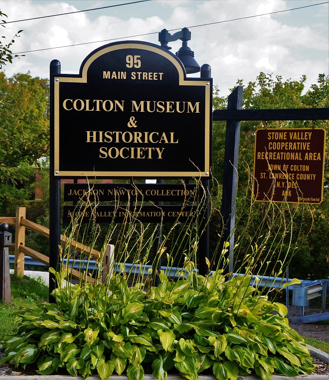 If you get a chance to stop at the Colton Museum & Historical Society building at 95 Main street, it will be well worthwhile. They have done a great job there and have a ton of information on Stone Valley and the town. They recently hosted a wonderful talk by Ed Fuhr, who was the son of the owners of the Hollywood Dude ranch. He recalled the history and his time at Hollywood until its demise.
For more on NPR’s Ed Fuhr interview – www.northcountrypublicradio.org/news/story/34595/20170911/north-country-at-work-sinking-the-lost-hamlet-and-dude-ranch-of-hollywood
For a PDF trail map-
https://www.stlawco.org/data/files/Departments/Planning/SVM-June%202011.pdf
I would like to thank Cynthia Hennessy of the Colton Museum & Historical Society for her help with this project. She was able to offer information and images that were vital to tell this story properly.
References & Sources
Ray’s Place-
http://history.rays-place.com/ny/colton-ny.htm
Colton Museum & Historical Society-
http://coltonareamuseum.com/
Northern NY Waterfalls-
http://www.nnywaterfalls.com/raquetteriver/stonevalleyfalls/
St. Lawrence County planning office-
https://www.stlawco.org/data/files/Departments/Planning/SVM-June%202011.pdf
New York State Historic Newspapers-
http://nyshistoricnewspapers.org/
North Country Public Radio- www.northcountrypublicradio.org/news/story/34595/20170911/north-country-at-work-sinking-the-lost-hamlet-and-dude-ranch-of-hollywood
“Colton, New York story of a town, II”– by the Colton Historical Society
About the Author
William Hill
I am a life-long resident of the north country, calling Edwards my home. I have always had a passion for the outdoors, and for local history. I recently started this site to share places that have been part of our local history and heritage. I hope you get a chance to hike some of these trails for yourself and reflect on the rich history of those that walked here before you. And if not, sit back and experience these from where ever you are right now. Either way, enjoy!
*ALL RIGHTS RESERVED*

Hi Bill,
Thanks for leaving a copy of your book for me. Great stuff!
Enjoyed this article as my wife is from South Colton and I often spent time on the Stone Valley Trail when I was in high school.
Jerry Manor
LikeLike
I’m glad you enjoyed it!!
LikeLike
Don’t you think that publicizing your favorite places will ruin them?
LikeLike
These trails are for for everyones enjoyment, and they were basing used long before I wrote about them. I’m not too worried about thembeing ruined.
LikeLike