Google maps link

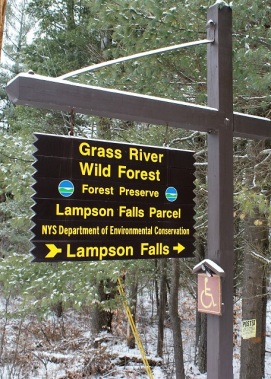 Lampson Falls is most likely the most popular waterfall in the area. Much of that is due to not only its easy access but its size. It is estimated to fall around forty feet and is about one hundred feet across. The New York State D.E.C. has done a tremendous job into making this accessible to everyone. While it doesn’t have a paved sidewalk, it does offer easy grades on a well-maintained dirt road, and there is a switchback section to view the falls even from a wheelchair. That section is built with pressure treated curbs, and filled with crushed stone, laid out to have a minimum grade to the overlook. It is located on St. Lawrence county route 27, about 4.5 miles north of DeGrasse. There is plenty of paved roadside parking (with several handicapped spots available).
See details at http://www.dec.ny.gov/lands/75300.html
History

Before Clare was a township of its own, it was a part of Clifton and Pierrepont. It was made official in November of 1880. In the township of Clare, at this time, there were also the communities of Gleason’s Mill, New Bridge- a logging village, and the short-lived iron mining community of Clarksboro (look for an upcoming feature on this). There were three schools in the area of what we now consider Clare. There was at one time a Tavern, a church, a hotel, and 2 different milk & cheese factories. At Lampson falls, there were several mills that made use of the great amount of water power at the falls. As with most towns & communities in the area, a location on a river was usually the first order of business. Many times, sawmills and gristmills were the first things established, and this gave birth to the settlement.

1865 maps show the area of Lampson falls as being owned by John S. Lampson. A Clare business directory lists him as “proprietor of a grist mill, sawmill. Dealer in all kinds of lumber, timber, shingles, flour, and feed”. Also listed in the same directory is an M.M.Daniels- manufacturer, and dealer of lumber, shingles, and staves.

Staves were used for wooden barrels and tubs. It shows on the East Pierrepont business directory a W. Lobell as a cooper (barrel maker) in the area. I also found mention of hoop factory (ran by several people from Canton) at the falls. Given that logging was an important part of the economy, the woods used at these mills would have certainly come from local forests. There was a sawmill on the North Branch of the Grasse River at Harper falls, in Downerville (look for an upcoming article on this).

As time went on, people left the area and took on work at factories and mines elsewhere, and in the industries, that supported them such as railroads, store, hotels, and schools. Today it is home to a few homes, and probably the seasonal camps in the area outnumber those. There are several large hunting clubs in the township and it is a hub for snowmobilers from all over. On our most recent trek through Clare on a Saturday in February, more than 20 trucks with snowmobile trailers were parked at the Clare highway department garage- which only employs two workers. Much of the land has been reforested, either by farmland being abandoned and allowed to grow or by state purchases and replanting of softwood trees. Logging is still a strong industry in the area.

On the trail
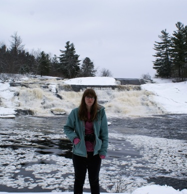
 As mentioned above, it’s a very easy 6/10th of a mile (each way) trip into the falls. Along the road in you will see some great white pine trees, along with some cedar, hemlock and even the occasional tamarack (or larch if you are from the western part of the country). Many glacial erratic boulders litter the landscape as well. You’ll hear the falls well before you reach it. There are many herd paths, so follow them to the river’s edge. The first one will give you a nice view of the top of the falls, and upriver as well. A little further will find you at the handicapped ramp, which gives an amazing look at the falls in full force. From there head down along the side of the falls to the bottom. In winter this will be icy, so use caution, and stay back a bit. At the bottom, you will find a nice natural beach and pool with even more views. If you turn away from the beach (North-east), the valley ahead has some of the most amazing white pine in the forest. It’s an easy bushwhack, although it’s wet, so walk on the high spots.
From the beach, a trail leads up to a rock outcrop that faces the waterfall directly. This is the best head-on view of the falls that you’ll find. This is also a nice spot to find wild blueberries in season. You can continue along the water’s edge to enjoy the river on its way downstream. A word of caution- this is not a water park. The beach is great, and the water crisp and refreshing, so enjoy it (in season of course)- but the falls are dangerous. Several people have been killed trying to play on the falls itself. Don’t add your name to the list.

This is a great easy hike, and you can take as long as you like here. If you enjoyed this, please share it with a friend, so they may enjoy it as well. Also, feel free to leave a comment or question. You can also find us on Facebook by clicking the tab on the upper right of this page or by following this link:
https://www.facebook.com/Hiking-the-trail-to-yesterday-1872362693001543

If you are looking for more to do in the area here are a few suggestions:
Tooley Pond road waterfalls
https://hikingthetrailtoyesterday.wordpress.com/2017/01/19/toohley-pond-road-waterfalls/
Harper Falls
http://www.nnywaterfalls.com/grassriver/harperfalls/
Downerville State Forest
http://www.dec.ny.gov/lands/97736.html

Reference, acknowledgments, and bibliography
A HUGE thanks to JeanMarie Martello at the St. Lawrence county historical association’s archives. She was able to provide me with some great information on this area and many others.
THANK YOU!
NYS Department of Environmental Conservation
http://www.dec.ny.gov/lands/40672.html
St. Lawrence county historical association (SLCHA)
The History of Clare excerpt by Charlotte Popp
(provided courtesy of SLCHA)
Northern New York Waterfalls
http://www.nnywaterfalls.com/index.htm
Historic Map Works
Slideshow
About the Author
I am a life-long resident of the north country, calling Edwards my home. I have always had a passion for the outdoors, and for local history. I recently started this site to share places that have been part of our local history and heritage. I hope you get a chance to hike some of these trails for yourself and reflect on the rich history of those that walked here before you. And if not, sit back and experience these from where ever you are right now. Either way, enjoy!
ALL RIGHTS RESERVED

Fun day!
LikeLiked by 1 person
Bill, which one of your hikes would make for a good snowshoe outing?
LikeLike
Harper and Lampson are both very snowshoe friendly – wide trails, and few obstacles. The only thing that Lampson has over Harper is the trailhead. Lampson’s parking is paved right on the roadside, and always plowed. Harper’s parking area is a half mile off the main road, and may not be accessible if we get much snow. I made it OK with my AWD Subaru , but we have gotten close to a foot of snow since then.
LikeLike
Also the Edwards nature trail is snowshoe friendly. Hart’s Falls is too, but it’s not very far.
LikeLike