Trout Lake State Forest
Google Maps link- https://www.google.com/maps/@44.3573046,-75.2584927,4455m/data=!3m1!1e3
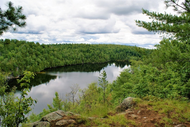
 The Trout lake state forest is home to two lakes, Trout Lake and Cedar Lake. Trout Lake lies entirely within the town of Hermon NY, Cedar Lake is shared by Edwards and Hermon. The lakes are quite different, but share the same character of a remote forest lake. Cedar Lake is the more quiet and serene lake of the two. Motors (gas) are not allowed there. You are much more apt to see a canoe or kayak. On my most recent trip to Cedar Lake, the first sounds I heard were of a pair of loons calling. There are plenty of camps & cottages at Cedar Lake, but few are right on the shoreline. These are built in the hills and ledges of the surrounding forest. Only a handful can be seen from the lake or surrounding overlooks. Trout Lake, on the other hand, is much livelier. Motorboats and jet-skis are commonplace, and camps line the shores. St. Lawrence County Rt.19 runs along the West shore of the lake, and many fine camps and homes can be seen driving past.
History
 Trout Lake
Trout Lake lay undiscovered (by white settlers at least) until sometime around 1860. It is said that Ezek Earl came across the lake while hunting wolves. By the 1880s, logging was in full operation here. John Gardner built a sawmill on the Trout lake outlet, replacing his early sawmill site at Gardner’s pond to the North. Apparently, this was a man-made pond as it is not shown on modern maps. This site was only used only in times of high water, often lacking sufficient water power to operate the mill. The mill was later operated by John Barber, then to Barnett & Moore of Potsdam. Under Barber’s management, the sawmill saw extensive upgrades. The new mill employed 35-50 men, and was powered by a 100-horsepower steam engine, and produced up to 20,000 board feet of lumber daily. As many as 100 French/Canadian loggers were brought in to cut timber in the forests. The lumber was hauled by 12 -15 teams to nearby rail sidings in Bigelow for railroad shipment. Pine and hemlock were the main species, although the local hardwood would have also been harvested for other markets.
The 1880s also saw the beginnings of Trout lake’s use for recreation. Asa Gardner and later, John Bradley operated the Trout Lake House, a hotel to accommodate travelers that came to vacation at the lake. There were several steamboats operating about the lake at this time, a ride costing 25 cents. In the winter months, horses and Ice-boats raced on the lake. In 1899, the town of Edwards appropriated the sum of $2000 to improve the 3 miles of road from the village to the head of the lake. The section known locally as “the flats”, led across a swamp, and was constructed by means of “corduroying”- laying logs crossways to keep from sinking into the mud. Fellows by the names of Tonk Lanphear and Hiram Hall provided transportation to lake from the village of Edwards. The New York Central Railroads G&O (Gouverneur and Oswegatchie) branch also brought people to the lake with special packages being offered. The Train station was located in the village of Edwards, and the last few miles of transportation would be included in this package.

In the early 1900s, Earl Bancroft purchased a logging camp. This was remodeled into a home, and at one time served as a restaurant. Bancroft was an attorney and often traded his services for properties on and around the lake. He was the one who bestowed the phrase “land of the white plume” on the lake. To him, the white plume stood for idealism & chivalry. He felt this was a better means of conducting one’s self and was expected of his family as well. The Bancroft holdings on the lake represented a place for this way of life to flourish. Bancroft employed Bill Grant to start construction on many cottages on the lake.
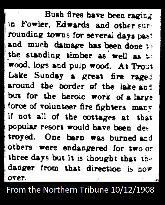
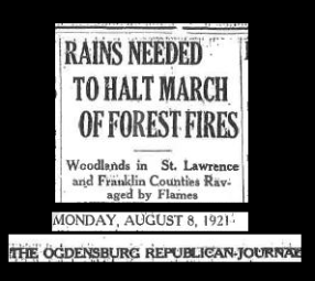 In the early 1900s, wildfires took many acres of land in the area. 1908 saw fires in October that threatened the lake. The 1914 April/May edition of the Canton commercial Advertiser featured the headline: “BIG FOREST FIRE AT TROUT LAKE”. The May 22nd dated article told that the fire was believed to have started at the Reed Brothers sugar house (what is now referred to as the Reed Ranch, located in the nearby Wolf Lake state forest.) Earl Bancroft and many others fought these fires for several days. The August 8, 1921 edition of the Ogdensburg Republican Journal carried an article telling of the forest fires that originated on the Woodcock brothers (of Edwards) property. It states the several hundred acres have burned, and the fires have burned deep into the soil, destroying roots. There was a second smaller fire at Huckleberry lake at the same time working towards Talcville. These fires gave the name to the nearby Fire-falls state forest and shaped the area as we know it today.
 Camps and cottages continued to be built and existing ones were expanded through the years, numbering over 100. The road has seen many improvements as well. The mills are long gone as well as the hotels and restaurants. At one time, the Boy Scouts had a campground on the Southeastern end of the lake. The site is a bit south of what is known as Boy Scout Bay today. In the 1940s the U.S. Army held maneuvers at the lake. These soldiers were from Pine Camp, now known as Fort Drum.
In 1969 the Bacons from Canton built a marina near the road. This has changed hands several times and is currently owned by “Captain” Dick Ashley. He purchased the property in 1975, and due to health reasons, has closed the marina in recent years. This was about the last commercial endeavor on the lake. A few individuals operate various part-time businesses out of their homes here today.
In the years between 1963 and 1976, the state purchased the parcels of property that comprise the Trout Lake state forest. These were purchased from the Brown, Bacon, Todd, and Grannis families. The parcels ranged in size from 8 to 856 acres in size.
For more on Trout lake’s history, find a copy of Land of the White Plume – By LaVerne H. Freeman

Cedar Lake
Cedar Lake was known as Chub lake at one time. The property was first owned by Thomas Noble. Noble, a Civil war veteran, gained the property through a government allocation program, for men who served in the war. The property changed hands but remained in the family for many years. There was a small homestead farm on the property south of Cedar Lake. This farm sat mostly on one the few level spots in the area. The last person to farm here was Silas Wood. This would have been a subsistence farm, with enough crops and animals to provide for the family. Wood would also work on other nearby farms with his team. He moved from the property in 1915 with his wife and three children. They were the last year-round residents of the area until recent years. In 1966, Mrs. Gertrude Beach sold the 235 -acre family property to Larry Clingerman, Cary Fletcher, John LeFevre, and Robert Mead. This would be known as the Cedar Lake Land Corporation. Construction began on roads, lots and camps on the property. The lots were sold to folks, but the roads and beach were collectively used by the association. A commons area and large building was constructed for use by all members. The association had bylaws to preserve to integrity and beauty of the area. The majority of the camps were designed with a reflection of the architecture of the time. Unlike the traditionally styled camps and cottages of Trout Lake, these were constructed as A-frames, asymmetrical roofs or hip-roof designs. The placement of the camps along the banks and ledges took some imaginative engineering. There is very little level ground to be found around the lake.

The rustic camps were cleverly built into the rugged landscape, and until recent years, had no electricity. My father (Albertie Hill) sold LP gas (propane) and performed excavation work with backhoe, dozer, and dump-trucks. In the mid-1970’s he was quite busy in the hills and forests of Cedar Lake. Most every camp use propane lights and refrigerators, and my dad serviced all but a few there. Building lots and driveways were built by my dad as well as seasonal road maintenance. He helped construct the beach there one winter, by carrying sand out on the ice with a loader, so in the spring when the ice melted, there would be a nice sandy bottom. This worked well until the rear wheels of the tractor broke through the ice. At 7 or 8 years old, my job was to steer the loader while he pulled it out with the dozer – this was my first time driving anything bigger than a bicycle! He also moved a camp for a family there. Sometime in the mid-1980s, the association held a party (possibly Labor Day) and he was the guest of honor. They gave him a rustic folk-art painting. This was painted on a canvas (that probably previously served as a cot or chair seat) and had a frame made of grey birch. This painting still hangs in my garage today, and I also own the tractor that fell through the ice and moved the camp.

There is a small mine-shaft under the road into the camps, probably for talc or iron in the early 1900s. There is a spring with a hand pump along this road as well. The pipe and the cement casement around the spring were placed by the Northern Ore Company, the predecessor of the nearby St. Joe zinc mines. A metal hand scythe blade was found embedded in the trunk of an elm tree, during the construction of the roads in 1969.
Today the camps have been modernized with electricity and drilled wells. Several are year-round homes. Still, the camps are built into the forests and rocks around Cedar lake and it is a tight-knit community. All of these camps and roads are on private property, so please respect that and don’t venture past the signs.
Getting there
 From St. Lawrence County Rt.19, turn Northeast onto East Shore drive. This is directly opposite of the Fire-Falls state Forest sign. Continue straight through the yellow gate for a half mile. The road does a roundabout at the end and this is where the hike will start. There is another route that comes in from the Campbell road, about 2 miles from St. Lawrence County RT24. There is a trailhead at the end of the access road. This is just past the NYS DEC field office. The access road starts at the Edwards/Hermon town line sign. The trailhead is 3/10th of a mile ahead. As with most DEC access roads, there are yellow mud gates on both of these and will be closed in mud season (fall & spring). Here is a Google Maps link to the Campbell road access: https://www.google.com/maps/@44.3665689,-75.2478205,253m/data=!3m1!1e3
On the trail
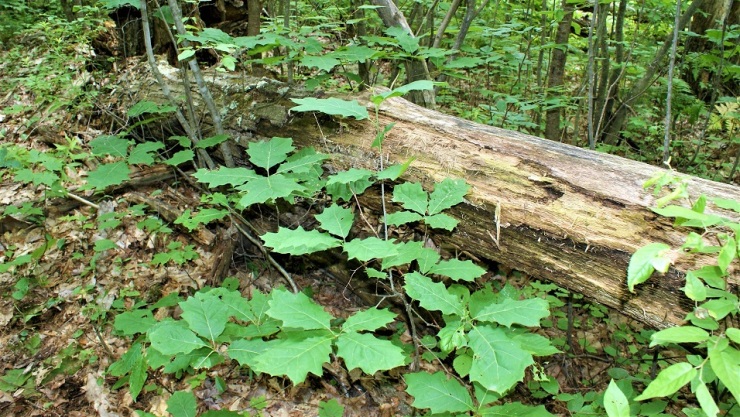
I started the hike at the Cedar lake turn around. There are several routes and combinations for you to choose from. At the parking area, you’ll follow the trail downhill, and within a couple dozen yards the trail splits. Right takes you downhill to the Cedar lake boat launch, about 2/10th of a mile. Just a side note, it is quite a difficult carry back up out of there with a canoe. The left trail leads through some rock-strewn crags to higher ground. The forest here is predominantly white pine (Pinus strobus) and red oak (Quercus rubra). The larger, mature red oaks are in pretty bad shape, due to damage from the January 1998 ice storm. The oak is a very hardy tree, and it took many years to succumb to the damage. Many are dead, but still standing. The forest will eventually heal itself if allowed, and this is already in progress. The forest floor has a great new crop of oak growing, and will eventually return to the way it was before the ice storm.
This area is no stranger to natural disasters. In 1908, a great forest fire swept through the area, not only burning the trees and plants but actually burning deep into the soil, down to the bedrock. In fact, directly West of here, across RT19, is the 1570-acre fire-falls state forest. This received its name from the fires that swept through the area in the early 1900s. [ http://www.dec.ny.gov/lands/82459.html ] This thin soil was adequate for the oak and pine to slowly reclaim the exposed ridge tops.
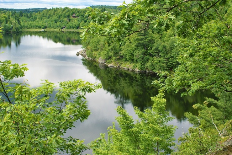
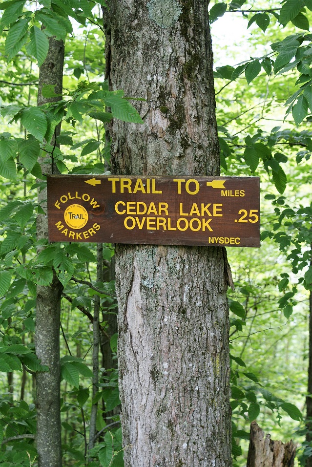
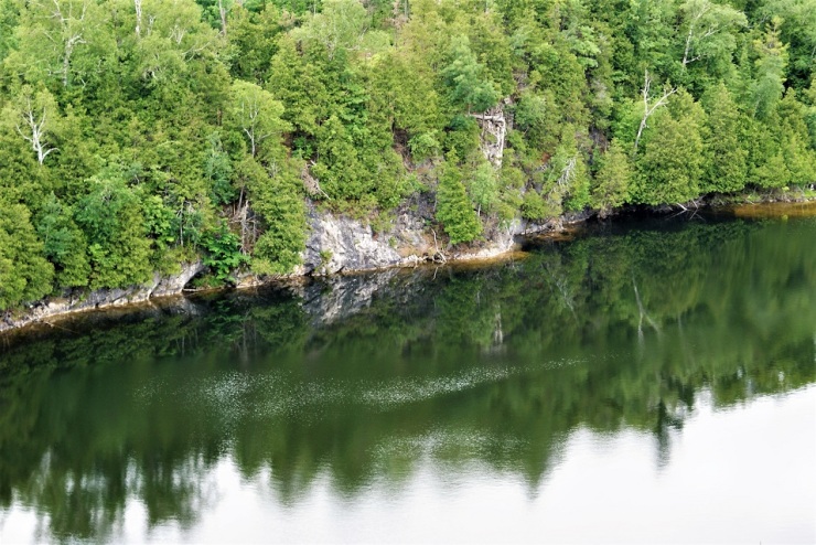
At about 2/10th of a mile, you will see the first overlooks of Cedar Lake. The views here are spectacular but very exposed. The lake is well over 100 feet below you, so use caution on these overlooks. A few of the camps & cottages can be seen across the lake, on the East shore of the lake. You can follow the trail further along, and experience more overlooks with new views – I turned around at the 6/10th of a mile point.
 On the way back, I took the trail down to the lake. This is fairly steep & rutted, but well worth it. The views are entirely different from those above, and still impressive. At lake level, you can really appreciate the scale of the ledges. Back at the parking area, the round trip total of this leg of the trek is about 1.4 miles.

Trout Lake trail to Boy Scout Bay
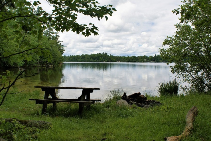
 The trail to Boy Scout Bay is 1/10th of a mile from the Cedar lake turn around, back towards the main road. The trailhead is marked with a sign and red trail markers. This trail is more of open hardwoods, mostly maples (hard maple- Acer saccharum and soft maple-Acer rubrum) and a few yellow birches (Betula alleghaniensis) & black cherry (Prunus serotine). The soil here is much deeper, and moister. In fact, the trail parallels a swamp most of the way. The trail is well laid out, to stay on higher ground, although due to the rains that we have had recently it was still soggy in places. At about the ¾ mile mark, you will get the first views of Trout lake through the hemlock trees. This bay is only 150 yards or so from the trail, so it’s worth it to walk down to the edge of the water. The trail leads uphill from here, and in another ¼ mile, you will arrive at Boy Scout Bay. It appears from my research that while this bears the Boy Scouts name, that the actual sight of their campground was further South of this bay. The bay here has a nice sandy bottom, a picnic table, and an outhouse. This is a nice winter destination on snowshoes as well as a summer hike. At this point, you are one mile from the trailhead.
Campbell road trail
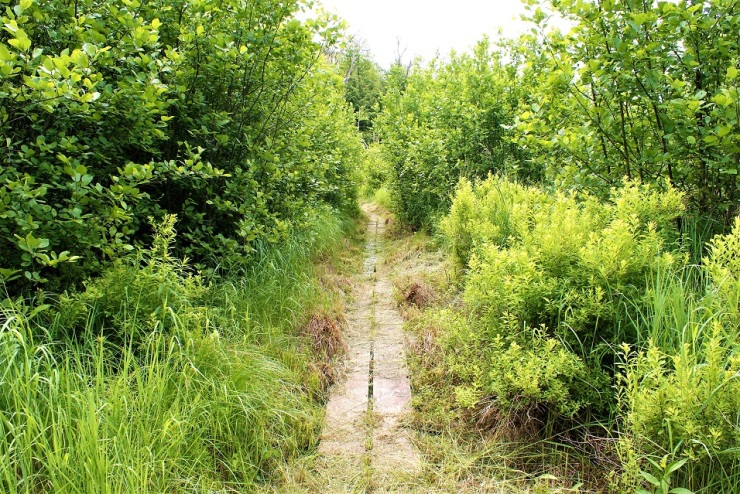

From Boy Scout bay, the red trail continues Southeast. Just after leaving the bay, the trail crosses the swamp that we paralleled on the way in. The DEC has placed a board-walk across this swamp and had recently weed-whacked the swamp grass. It was still wet in spots even on the boardwalk, but this year has offered an exceptional amount of rainfall compared to most years. After crossing the boardwalk, you will go uphill to terrain that is rockier and reminiscent of the Cedar Lake trail (which is only a half mile South of here as the crow flies). There is a great deal of beaver activity along this route. The first thing I heard here was the croaks of the bullfrogs coming from the beaver ponds. The trail continues Northeast from here and eventually comes out at the Campbell road parking area & trailhead. This is a half mile from Boy Scout Bay and 1.5 miles from the trailhead.

You can mix & match these trails to your liking, I hiked them all on this last trek, and it totaled 4.6 miles altogether, with 450’ of vertical elevation gain. This is a pretty sparsely visited state forest compared to many of the others near lakes. Enjoy its quiet solitude, and reflect on what the years past have contributed to the forests & waters we have today.
A special word of thanks Tony Sparacino (NYS DEC). He provided a great deal of information that was very useful in the preparation of this article.
References
New York State Department of Environmental Conservation
http://www.dec.ny.gov/lands/104571.html
Land of the White Plume – By LaVerne H. Freeman
http://edwardshistory.org/index.htm
The St Lawrence County Historical Association
Quarterly magazine, January 1971: The Trout Lake Story- By Leah M. Noble
Early Lumbering in the town of Hermon- by Mrs. Kellogg Morgan, 1957
the Trout Lake Association
http://www.troutlakeny.com/trout-lake-history.html
New York State Historic Newspapers
http://nyshistoricnewspapers.org/
Watertown Daily Times
http://www.watertowndailytimes.com/ogd02/local-angle-dick-ashley-20151020
Welcome to Cedar Lake– by Bob Mead, 1971

About the Author
William Hill
I am a life-long resident of the north country, calling Edwards my home. I have always had a passion for the outdoors, and for local history. I recently started this site to share places that have been part of our local history and heritage. I hope you get a chance to hike some of these trails for yourself and reflect on the rich history of those that walked here before you. And if not, sit back and experience these from where ever you are right now. Either way, enjoy!
*ALL RIGHTS RESERVED*

Thank you for the great synopsis. My father Arthur Frederick had been visiting Trout Lake since the early 1940’s. Until WWII. Afterwards graduating from Clarkson College of Texhnology and later St Johns Law.
Doc Spencer was originally from Dekalb Jct. But moved to teach in Westchester. Dad was a student of Biology and Physics from Doc.
He and HS buddies were invited up and fell in Love with Trout Lake.
After years of renting at Ponds, Manzolati, and Turnbull. We cleared land on Leader Lane for a log home in 1998.
Though Dad and Mom have passed on, I still own the home and continue to maintain it. Taxes are an issue of dollars and I Rest the home 7-10 weeks in the summer to defer costs.
Dad contracted your father Alberti Hill to drop a lot of truck loads of fill on the property. He was a very nice guy and was full of stories.
I started coming to Trout Lakebin the early 60’s and have been coming up ever since. I’m 65 now.
I hope to coming up many more years to come.
Rick Frederick
20 Leader Ln
LikeLiked by 1 person