Google Maps Link
https://www.google.com/maps/@44.133955,-74.9232106,17z

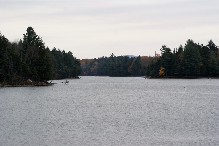
Wanakena on the Oswegatchie
Located in the South-east corner of St. Lawrence County, Wanakena NY is a small Hamlet, with big woods, and big history. The big woods are what put them on the map. The place started out as a haven for sportsmen and lovers of the outdoors and became an industrial boom town. After all was said and done, it has returned to its beginnings. Things are much quieter than the days of industry. There are three things that really define this town, and we’ll deal with those in a bit. No more trains. No more mills. Gone are the logging camps. What has not changed is that everything here still centers around the woods & water. Be it the hearty families that call this place home or the folks coming to spend a day, week, or summer here- they all are here for the same passion for the forests and rivers. I could go on for the length of a novel about this town, but instead, I’ll try to give you a taste. There is plenty of information available should you choose to learn more. Just don’t ask what the name “Wanakena” means. It seems that it is an Indian name, but nobody seems to know for sure of the meaning. Visit the place once, and decide on your own meaning.
History
 Before the 1860’s the area was only known pretty much to woodsmen and guides. This region was referred to as the South Woods (along with Cranberry Lake and Tupper Lake). There were only trails to the region. About this time a stage-coach line worked its way to the region from Canton NY, a two-day rough passage. This route was the beginnings of what we now know as the Tooley Pond road. Mining was starting in the region as well and this brought more people to the area. In 1867 a dam was built on Cranberry Lake, raising the level of the water. This made the lake even more attractive to the fish & game. The Carthage & Adirondack railroad had expanded its rail into Benson mines (in the town of Clifton) by 1889. Within the next year, a road was constructed from Newton Falls to Cranberry Lake. All of these played a part in the growth of the area as a tourist destination.

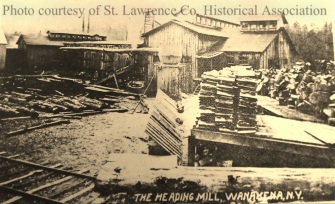
In 1901, brothers Herbert & Horace Rich, (the Rich Lumbers Company) experienced lumber barons made their way here to look for timber. 16’000 acres were purchased and construction started the next year. The village was built on the banks of the Oswegatchie River, which flows into Cranberry lake. Men and materials were shipped from Pennsylvania and construction began on the company store and homes for the workers. Nearby Skate creek was dammed up to form a mill pond. While the Rich Lumber Company was handling the logging and setting up the town, the millworks were under contract to other companies. The Ford brothers set up and ran the two sawmills. They employed a millwright by the name of J. Otto Hamele (more about him in a bit). Other operations were set up including a veneer mill (cutting yellow birch), a whip butt mill (making buggy whip handles from beech lumber), a shoe last mill (making wooden shoe forms), a lath mill (for plaster laths) and stave & heading mill. Staves were manufactured for wooden barrel construction, and the heading mill produced the barrel tops & bottoms. The waste & slab-wood was chipped and sold for paper pulp.
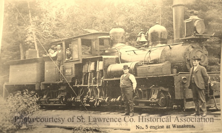
 Railroad lines were built to haul the logs into the mills, and to connect with the Benson mines line. This allowed travelers to come from all over to Wanakena and enjoy the wilderness. There were nearly 40 miles of rails laid to serve the town. The community grew rapidly, and at one time it is thought that over 1500 people employed in the areas associated industries, including 500 people living in the village. A 171 feet long suspension footbridge was constructed to join the north side (village) with the south side (mill side). This in time would become an icon of the town.

The logging was intense and the forests were being cleared at an incredible rate. As was the common practice of the time, when the timber was gone- so was the company. In 10 years’ time, the Rich Lumber Company had used up the resources and moved to new forest holdings. The mills closed and people moved away. The rails to Cranberry and Benson Mines were taken up. This slowed tourism greatly. The next hurdle to clear was what to do with the deforested properties. Remember Otto Hamele?
Otto’s Legacy


When the logging company moved its operations to Vermont in 1912, Otto was left in charge of their Wanakena land holdings. He had a keen awareness of the forest and was very progressive in his environmental thinking by the standards of the day. He understood the need to manage forests to produce timber but to still have forests left for tomorrow. He had a vision of long term goals that made sense for everyone.

It was thinking like that, that enabled him to have 1800 acres gifted to the College of Forestry at Syracuse. This would be used to study the forest, the production of timber, reforestation, and ecology. This was the first school in the United States to teach what would be known as sustainable forestry. The school also would teach students to become Rangers, and thus became the Ranger School. The school became the standard by which others would be judged and is still considered among the finest in the country. The school would start a tree nursery, and use these seedlings to reforest the area. This can still be seen in the forests of the region today. The school was off to a great start. The rest of the land holdings would eventually be purchased by the state, and these were managed with help from the Ranger School. They also were involved with the Emporium’s forestry vast operation at Cranberry Lake. The school has become the first thing people think of when you mention Wanakena.
If brokering the agreement between the Ranger School and the Rich Lumber company was the only thing that Otto Hamele had done, that would still be plenty. But it wasn’t. The road you came in on, NYS Rt.3? That was the former railroad right of way, and he donated it to the town of Fine after the rails were removed. The bridge over the Oswegatchie river? That was the railroad trestle. He was instrumental in bringing electricity to the hamlet. He brought free spring water into the faucets of the homes. He was active in the much-diminished church, filling several roles ad the population dwindled. He was active in local politics, and many organizations involved in the region’s affairs. He was a true champion of community and history. I could continue with an endless amount of great deeds that he provided, often with little or no pay. For more on Otto and his contributions, get yourself a copy of Brad Woodward’s The Ranger School: A Century in the Forest. The Ranger School and J. Otto Hamele are two of the iconic symbols of Wanakena, and the third?

The Wanakena Footbridge
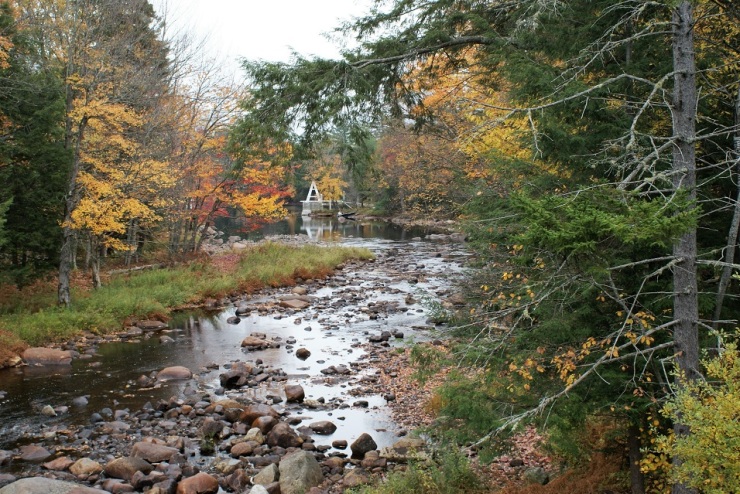
In 1903 a footbridge was constructed to join the village with the mill side of town. Little did anyone think at the time that this would become an icon for the town. This was merely built as a convenience, yet has become as well known as the Ranger School. I can’t remember a time in my lifetime that I didn’t know about the bridge. As a child, I used to love to run from one end to the other. Now I walk and enjoy the scenery, the serenity, and the savor the history that has passed over (and under it). This was said to be one of the longest suspension footbridges in the United States. It was featured on postcards for generations. It was even listed in the National Register of Historic Places (along with the church). In January of 2014, the footbridge was destroyed by an incredible ice jam. The village wasn’t about to let go off this piece of their heritage. Groups began to raise money, grants and funding were applied for, and with support from all over the bridge was reconstructed to finish in November of 2016- less than two years, start to finish.
 Now a small hamlet, Wanakena still thrives (at its own pace). There is “Otto’s Abode” a store-slash- art gallery. There are plenty of activities happening around town. You can grab a pretty nice meal at the Pinecone between town and the Ranger School. Tourism still helps drive the community. There are miles and miles of trails, to places all over the compass. Camps, boats, ATV’s, snowmobiles, hikers, hunters, and fisherman all find this place as the great South-woods that it was at the beginning of the 20th century.
On the Trail
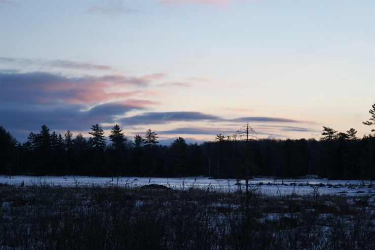
My latest visit to Wanakena was on Presidents day. It was a crisp February day, in mid-20 degree range, warming to the low 30’s. The day started out with a great with a spectacular sunrise and later turned to a bright cloudless day. Perfect day for a hike. There are miles & miles of trails here, but I couldn’t do them all, so I narrowed it down. My first objective was the Cathedral Rock fire tower.

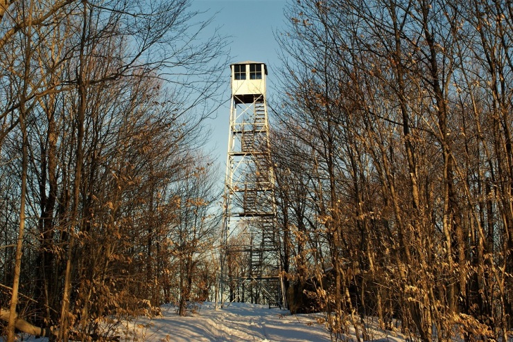
Cathedral Rock Fire Tower
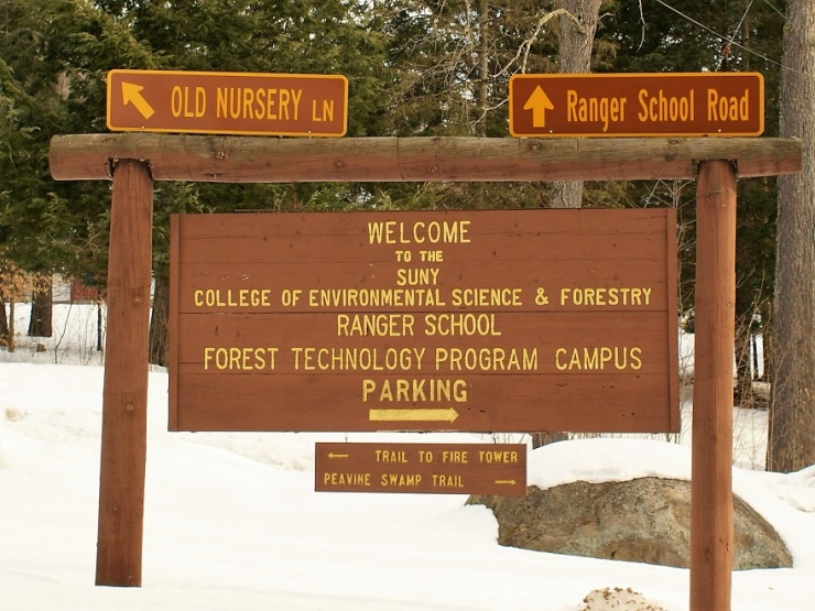
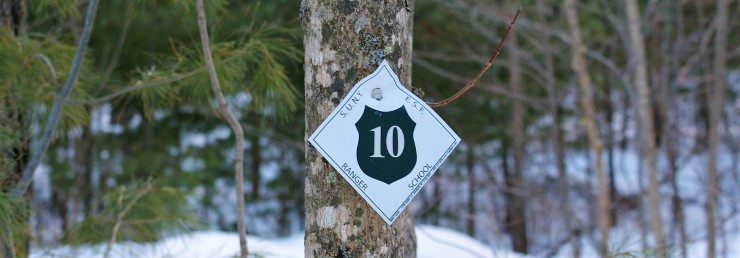
This is on the Ranger School property and is open for public use (along with many other trails). This was removed from Tooley Pond mountain and finally reassembled in 2000. The trail to the tower is the Latham trail (trail marker #10). You start at the gate at Old Nursery Lane, near the parking lot. There is a sign to help out on the way in. The trail is 2.2-mile round trip. It’s an easy stroll through the “classrooms” of a forestry school. You’ll notice numbered posts along the way. These mark different forests plantings. I brought snowshoes, but the hard-frozen trail was fine without them.
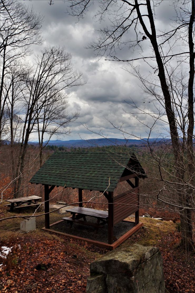
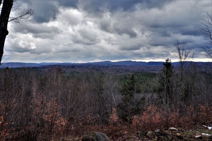
The final push was climbing Cathedral Rock. Signs warn on slip and fall hazards, and it would be easy enough to fall. The trail is narrow, and on this day icy. I would have brought my crampons (ice spikes) had I known. In summer this would be much easier. Once on top, you’ll find a little gazebo and picnic table.

You also will find a memorial plaque that marks the tragedy of a young hiker that slipped to his death here. It should remind you to respect the woods and use caution when outdoors. From here it’s a couple hundred yards to the fire tower. This is restored very well and is quite a sight against the background of the sky. It is open to be climbed by the public, though I passed. I’m not much on heights, and the steps had some ice on them….so I enjoyed it from the ground. Use plenty of caution descending, and especially in winter. I was about an hour and ten minutes, round trip, with much of that used taking photos. The tower has become a regular destination for me, visiting several times a year in every season.
For more info on the Cathedral rock fire tower, follow this link https://hikingthetrailtoyesterday.wordpress.com/2017/12/05/cathedral-rock-fire-tower/
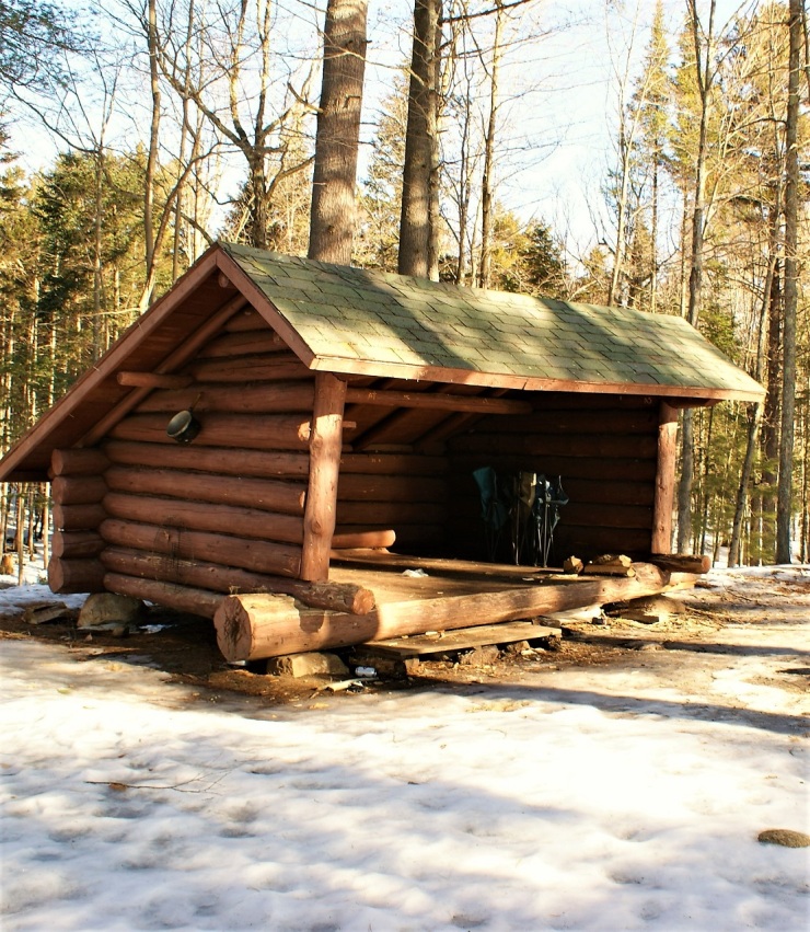
Peavine Swamp
Lean-to

My next jaunt was to the Peavine Swamp trails, at the far end of the campus. The Oswegatchie is quite wide in front of the Ranger School campus. Just before the sugar house (yes, they sugar here for maple syrup) you’ll see the signs for the trails. I started out along the shore and entered some mixed forests, with large hemlocks and yellow birches. It’s an easy stroll with little elevation gains. Trail marker #1 is what you are following until you see a sign for the lean-to at about one mile in. From here it’s a quarter mile to the lean-to. The final stretch leads through some small, dark timber. It’s a great spot for it, unfortunately, the lean-to has been treated like so many in the area. Why people feel the need to carve and write on the lean-to and leave garbage & beer cans laying around. Pack it in- pack it out, and leave no trace. I went down to the ice’s edge and saw four deer crossing the river a couple hundred yard away. You are close to Flatiron point, and Cranberry Lake. There are some wonderful views in both directions. Round trip was 2.8 miles, with plenty of wandering around and taking photos.

Downtown
 From here I headed down to the village. There are several picture kiosks around town and a self-guided walking tour. The first order of business was to the footbridge. They did an amazing job on this. It is a very accurate reconstruction, with modern building techniques. Directly across takes you to the mill side of town. You will see another kiosk with a wealth of information on the industries of the town. Take the time to really read the postings. The skate Creek mill pond is directly behind that. Heading down the South Shore road takes you to the trailhead for Inlet and many other trails. Many of these follow the old railroad beds, to the logging works of the Rich Lumber Company. The bridge gives you a nice view of the footbridge and the island. Back into town, it was nice to wander past the old homes and back to the footbridge. A little further down is a nice little overlook with several benches. It was in this area where the boat landing was. I did miss “Otto’s Abode” though- they are closed on Monday’s. It’s a good excuse to come back another day.
All in all, it was a great day on the trail. History is literally behind every tree. This was my first trip to these destinations, but I have made dozens of treks since then, and still enjoy every one of them. I hope you get to visit Wanakena, and I hope you enjoyed my article. If you did please share this with a friend.

Slideshow
Reference, acknowledgments, and bibliography
St. Lawrence county historical association (SLCHA)
NYS Department of Environmental Conservation
http://www.dec.ny.gov/lands/34715.html
Wikipedia
https://en.wikipedia.org/wiki/SUNY-ESF_Ranger_School
https://en.wikipedia.org/wiki/Wanakena,_New_York
https://cliftonfine.wikispaces.com/The+History+Of+Wanakena
The Ranger School: A Century in the Forest
By Brad Woodward
Logging Railroads of the Adirondacks
By Bill Gove
http://adirondack-books.com/gove.html
About the Author
I am a life-long resident of the north country, calling Edwards my home. I have always had a passion for the outdoors, and for local history. I recently started this site to share places that have been part of our local history and heritage. I hope you get a chance to hike some of these trails for yourself and reflect on the rich history of those that walked here before you. And if not, sit back and experience these from where ever you are right now. Either way, enjoy!

I remember the times my Dad and Uncles (along with myself) used to take the trail or the river to High Falls. I do not remember how many times I have been there, one time while I was in the Boy Scouts we walked in and had a blast. The river trip was long about 25 miles as I recall and was a great adventure, walking in was about 6 miles but lots of fun. Of course fishing and exploring was the highlight of it all. This was in the late 50’s and early 60’s oooohhhh the good old days!!!!!
LikeLiked by 1 person
I was born up and brought up in wanakena, but haven’t lived there since I was 17. I have told my kids many times that they don’t know what they missed being raised there. My grandfsthet, Sherman Hazelton was one of the first residents and my mom, Alice Hazelton taught school for many years. ..we just returned to walk the newly replaced swinging bridge. It just wasn’t wanakena without it…..sure did enjoy the article…
LikeLiked by 1 person
I’m glad you enjoyed it!
LikeLike
Laura, I’m Connie Flood (now Brown). I knew you when we were teens, along with Biddie, Sally, May Susan Ann Marie, Janet, and Doris. Many happy memories! I still come to Wanakena every summer; my grandchildren love it as much as we always did.
LikeLiked by 1 person
Really enjoyed all the information….Have lived in Wanakena and now return each summer. Always great to be back.
LikeLiked by 1 person
I’m glad you enjoyed it- summer will be here before you know it!
LikeLike
My Dad was a 1969 Graduate of Ranger School and took us nearly every year for the reunion weekend. Wanakena holds not only some of his best memories but mine as well. I was so proud to be able to contribute even a little to the bridge rebuild even though I now live in NC. Thank you for this article, I hope to be up there in 2019 for my Dad’s 50th Reunion!! 🙂
LikeLiked by 1 person
These comments reflect why Wanakena has lasted and still remains a beloved place to so many. Thank you to all folks sharing these comments and memories.
LikeLike
Very nice, thank you for your effort ! My family history has allot of Wanakena in it. My Grandfather, Great Grandfather, and several other relatives on my Mothers side worked for the Rich lumber company. My Father worked as a hunting guide on the south side of Cranberry lake. My Favorite excursion is the upper Oswegatchi to High Falls.
LikeLiked by 1 person
This is a wonderful article, but you left out what I think is the most importtant feature of Wanakena – its people. Wanakena would never exist if it were not for its people – both the full-timers and the “summer people.”
When we first discovered Wanakena 16 years ago, I was struck by how welcoming Wanakena residents are. They are proud of their town, incredibly eager to preserve it, and eager to share its history. When the footbridge was destroyed, everyone related in any way to Wanakena pitched in with money, time, creativity, energy, knowledge, experience, and plenty of baked sales and fund raising events to be able to rebuild the bridge three years later!
They are hardy folks; managing through the -30 degree winters, driving 30, 40, 50 miles each way to the decreasing number of jobs in the region, and helping each other in crises. They support their neighbrs and offer their time, resources, and advice whenever they see a need or are asked. Each person contributes to make Wanakena what it is.
If I may quote Dave Ziemba…Wanakena’s incredibly dedicated store owner, water and sewer system manager (unpaid), and with his family, planner of countless annual events and bondfires on the village square:
“Wanakena is small enought that everybody counts.”
He is absolutely correct..
LikeLiked by 1 person
This was a beautiful story about a beautiful place. I grew up in Wanakena. As a kid, we were always hiking somewhere. One memory we always liked was going to the sugar shanty. Mr.Apple would give us a taste of the sweet syrup. I have very fond memories of Wanakena and the people that use to live there. Thank you for your story.
LikeLiked by 1 person
I’m glad you enjoyed it, and thanks for leaving a comment.
LikeLike
Also read “Man of the Woods” by my father-in-law Herbert F. Keith for more info on the area. He was one of the last guides in the area. His aunt Ada Keith was married to Otto Hamele. Yale Point, where I live was the original camp on the river, accessed from Cranberry Lake before Wanakena came into being.
LikeLiked by 1 person
I will look that up- thanks for the suggestion.
LikeLike
Take a look at my project: http://www.thewaytowankena.com
Wish you had been able to reference it in your piece.
And thanks for your great article!
LikeLiked by 1 person
I will give it a look.
LikeLike
I so enjoyed this little bit of history on Wanakena as it holds so many of my childhood memories. I now live in Canada but often take a drive to see this beautiful little town. Special memories of boat rides on the river, the bridge and the Ranger School where my grandmother was the cook and my cousins met their spouses. Thanks again for the memories!
LikeLiked by 1 person
This was such a pleasure to read, a great synopsis of the history and soul of Wanakena, well written and representative selection of pictures. I grew up in Fine, married a man who grew up in Wanakena, his mother and grandmother having worked in the Ranger School kitchen. We now have a camp on the South Shore Road. It is a favorite place of our children and grandchildren. I told them all that this is a must read.
Wanakena is a real refuge in this increasingly fast-paced and impersonal world. You captured this in your article–keep up the good work–look forward to your next article.
LikeLiked by 1 person
Thanks for the kind words!!
LikeLike