Gulf Brook
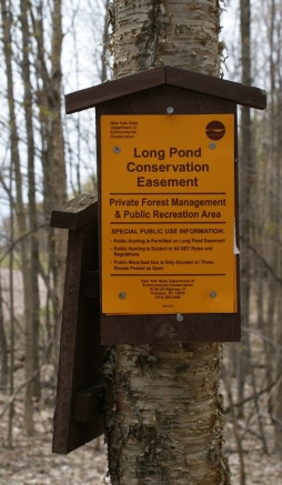
Gulf Brook is in Clare, some of it is in Colton. Early in History some of it would have been in Pierrepont before Clare was formed as a township. It is part of the headwaters of the Grasse River, it flows into the north branch of the Grasse. It is some beautiful and rugged country. Much of it is thick as a jungle to travel through. The access is made possible through several New York state DEC easements, Long pond easement, and the Grasse River easement.
 Then there are the Grasse river fishing easements to factor in. Some easements are only accessible for certain times of the year. The route (once you figure one out) is unmarked, unforgiving, and in places pretty treacherous. My first attempt missed its mark by close to a mile. That resulted in six miles for nothing. You will get your feet wet, chewed on by bugs, and swatted by brush. You better be handy with a map & compass. Once you get into the “gorge”, GPS will not get a reliable signal due to the high walls of the brook. Normally I would give a detailed description of the trailhead & route. Not this time. This is a rugged and often miserable bushwhack, so this time I’m leaving that part out. It’s beautiful once you get into the heart of the brook & gorge, but it is also dangerous and not for the faint of heart. A truly serious hiker can figure it out- I did with some help. I would not want to be a party to someone getting lost, hurt or in trouble for trespassing if they chose a wrong route. I’ll include plenty of pictures, highlights, and history, so sit back and enjoy this from the comfort of your home, and if you try it on your own- good luck and be well prepared.

History
Gulf Brook is in some the country that formed the settlements of the area. Gleason’s Mills, the ore bed road, Selleck’s upper & lower camps, Pleasant Lake and stone dam are all in the area. Logging was one of the first industries in the 1800s, the vast expanses of virgin timber were a calling card for the timber barons of the time. Iron mining played a part as well, with several mines of various size and success.

Today much of it is still used for forest products, only today things are managed with an emphasis on conservation and sustainability. It has long been a mecca for sportsman in pursuit of the areas fish & game. The area is still comprised of large tracts of land incorporated into hunting clubs. One of the oldest being the famed Stillwater Club. The easements have allowed public some limited access to thousands of acres previously off limits.
Gleason’s Mill

Gleason’s Mills is North of Gulf Brook, near the North Branch of the Grasse River. Sometime around 1860, a Mr. Morgan built and operated a sawmill here. In 1892, Lansing Gleason and his son Earl purchased the mill. They ran the mill here until the father’s death in 1928. The school served the families here until 1912. Iron ore was hauled through here from the ore beds (namesake of the ore bed road) further south near the Middle Branch. The ore was transported by teams of horses to Potsdam, then to Sackets Harbor by rail.
Gil Selleck

No writing should be done about this area without mentioning Gil Selleck. Born in Parishville NY in 1858, he was a true woodsman. He hunted, trapped, fished as a way of life. He earned money for supplies (flour, ammunition, salt & lard) by harvesting ginseng & spruce gum, growing strawberries and making maple syrup. Spruce gum was used much like chewing gum, and there was a processing plant that purchased the hardened spruce resin in Russell at the time. He maintained to camps in the area, referred to as upper & lower camps. The upper camp (Southern) was near Pleasant Lake, the lower (northern) was near Gleason’s Mills and Gulf Brook. These are still referred to on the DEC long pond easement map. [http://www.dec.ny.gov/lands/91866.html] For his own entertainment, he played the fiddle, until it was stolen from his camp in 1922. He was always looking out for forest fires, which were common in the area at that time. In 1908 fires consumed around 11,000 acres of forest in the area. He hiked the miles between his two camps every other day to check for fire, and fortunately, his area was spared. In the fall of 1925, he was found sick of pneumonia in his camp and helped out to town to recuperate. Although not fully over his ailments, he returned to the upper camp in early January. Later that spring, in early March of 1926, a logging crew found him deceased. Today his name lives on in maps of the region, his camps and in the naming of the Selleck road.
The Stillwater Club

 The Stillwater club is an icon of the area. It is comprised of nearly 15,000 acres of forest land. Started as a club for those who enjoyed the wilderness, the group of men from Canton had an early concern for the conservation of the forests, ponds, and streams as well as the wildlife. The club was started in the spring of 1893. There are two camps, one on the North branch and one the Middle Branch of the Grasse River. These were (and still are) very nicely kept, and had guides to help the sportsman in their pursuits. If you drive up the Dean road in Clare, you’ll see a sign hanging from a rock cliff bearing the club’s name, and further up- the middle branch camp and its long footbridge. Today, much of the property has been opened up to snowmobiles and fishing via DEC easements.
On the Trail

I have heard this described as the “Grand Canyon of St. Lawrence County”. The bushwhack to the gorge is typical of a river bottom of the area, wet, brushy and buggy. There are ATV trails that get you to the top of the gorge, with nice views. To really appreciate it, I choose to enter to the bottom well before the cliffs. Once in, there are very few places to climb out of the gorge proper, and they are not to be taken lightly (I didn’t even try). I chose to stay on the northern bank of the brook. As I hiked, I doubted if you could follow the southern bank. Often the walls of the gorge fall directly to the water’s edge. If you could find a level spot over a foot wide, it was rare. The stream bed is a litter of sharp, moss-covered boulders and vegetation.
 Fallen logs are everyplace. The trail itself is as you have probably guessed pretty brutal. The black flies were as thick as smoke, and apparently quite immune to 40X DEET bug dope. The silver lining to all of this was the beauty of the brook itself. The cool clean waters are the typical tannin-stained waters that we see in the region. Tannins are from the plants of the region, hemlock being a major contributor. Hemlocks were logged early in the history of the region only for the bark- the tree was left to rot. This bark was used for tanning (hence the name) leather and important item in that day. Tanneries produced leather for many things, namely shoes and harnesses for the horse-drawn equipment of the day.
 The walls of the gorge are probably well over a hundred feet tall in many places, with trees right to the very edge. Some walls are sheer, others a rubble-filled boulder field. It seems that every shade of green is represented here. The pine, spruce, hemlock, ferns, and moss all offer their unique play on the color. The gorge runs east-west, so the morning sun shined perfectly downstream. The gorge seemed to offer the GPS some issues, but probably the morning’s hike was about eight miles, as best as I can figure. Although I returned to the car wet & dirty, scratched and bug riddled, and tired- I came away with a contented feeling that truly wild places like this still exist.
 Once away from the car, there was no sign of any person having been here before. No litter, no signs, not even a footprint. A brutal bushwhack, to a wilderness oasis. Now for the long, bumpy car ride back to civilization. (FYI- don’t try this with your mini-van). I hope you enjoyed this armchair hike through some rugged territory of yesterday.
References & Credits
NYS Department of Environmental Conservation
http://www.dec.ny.gov/lands/40672.html
St. Lawrence county historical association (SLCHA)
About the Author
William C. Hill
I am a life-long resident of the north country, calling Edwards my home. I have always had a passion for the outdoors, and for local history. I recently started this site to share places that have been part of our local history and heritage. I hope you get a chance to hike some of these trails for yourself and reflect on the rich history of those that walked here before you. And if not, sit back and experience these from where ever you are right now. Either way, enjoy!